


Story of the vanishing rivers – Saraswati and Adi Ganga of Bengal

World Rivers Day is celebrated on the fourth Sunday of September every year to increase public awareness about rivers and to encourage their conservation. This year September 26 heralds the World Rivers Day. The annual event is marked by celebrations in more than 60 countries, and the participation of millions of people. But why do we need to dedicate a particular day to celebrate Earth’s waterways specially in India?
India is a land of rivers and existence of our civilization rests on our rivers. Ganga is the lifeline of the country that provides water to 40 per cent of India’s population and supports one of the most fertile and densely populated regions on the planet. The river carries nutrient rich sediment as it flows, depositing fertile soil along its shores. But what is the state of Ganga and its tributaries now? Swarnali Chattopadhyay, National Awardee Teacher (2013) who is presently working as a Director of RSGIS (an organization that deals with Cartography) says: “The present state of rivers in both Bengal and India are a great cause for concern and if we do not take immediate course of action to keep the rivers healthy, every river will face the fate that River Saraswati of Bengal did.”
Dr Jayanta Sen, a well-known geomorphologist, who has extensive research work on Ganga River Basin, says: “Till about a century ago, our interaction with rivers did not endanger their existence. But our industrialization, urbanization and developmental work have created existential threat to rivers.
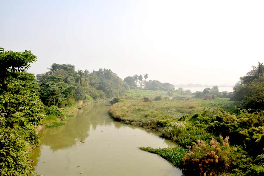
While speaking of Saraswati, Chattopadhyay emphasized that Saraswati River of Bengal is distinctly different from the Saraswati River that originated in the Shivalik Ranges in North India and moved to the western part of the country. “At Tribeni, near Bandel, the Bhagirathi branched off into three streams: Bhagirathi, Jamuna (this is distinct from the river of the same name in northern India and several streams of the same name in eastern Bengal) and Saraswati. Saraswati flowed south-west beyond Saptagram, Jamuna flowed south-east, past the northern boundary of Kalyani and Bhagirathi proper meandered through present Hooghly channel to Kolkata and then through Adi Ganga, past Kalighat, to the sea.”
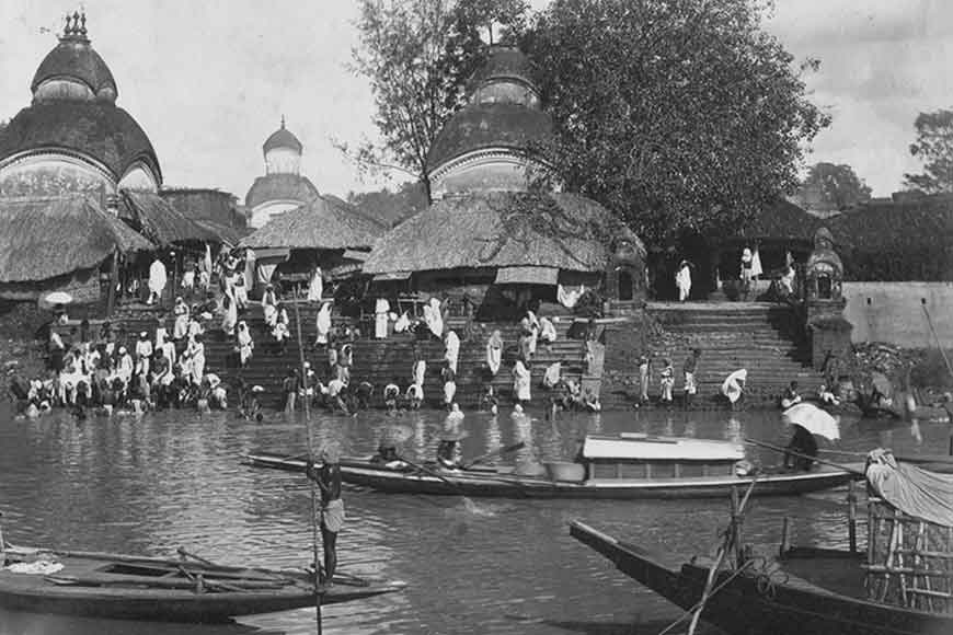
 Saraswati River
Saraswati flowed into an estuary near present-day Tamluk and received the waters of not only the Rupnarayan and Damodar but several other smaller streams. The course and condition of Saraswati played an important role in the development and decline of river port towns in medieval Bengal. In the 8th century, Tamralipta was a major port town but lost its importance primarily on account of silting up of the mouth of Saraswati and the consequent shifting of its course. In the course of time, upper Saraswati dried up. Bhagirathi or Hooghly abandoned the old Adi Ganga channel as well which is now slowly dying.
While speaking about the greatest threat to rivers today that are endangering their very existence,
Dr Jayanta Sen, a well-known geomorphologist, who has extensive research work on Ganga River Basin, says: “Till about a century ago, our interaction with rivers did not endanger their existence. But our industrialization, urbanization and developmental work have created existential threat to rivers. This threat comes in the form of big dams, diversions, chemical pollution from agriculture and industries, large dose of sewage pollution at major urban centers, encroachment on floodplains, deforestation, unsustainable groundwater use, riverfront developments, embankments, and climate change. What humans have done to rivers in the last century can be described as Terraforming (one of the grandest concepts in science fiction in which “advanced” societies reshape entire planets to suit their needs), or what some geologists describe as Anthropocene, meaning a new geological age of humans to suggest that humans are now a planet transforming force.”

During British rule, many rivers in Bengal were embanked in an attempt to combat the annual flooding, including the Damodar. These embankments did ensure security against low-intensity flooding, but the long-term effects were detrimental, leading to the decay of river systems and congestion of drainages. The parallel embankments along both banks of rivers restricted the spill area and interrupted the sediment dispersal on the floodplains posing a great threat to the agrarian economy of Bengal. The areas trapped within the embankments were gradually elevated by the deposition of sediment load while the adjoining parts of floodplains remained at the same height and thus aggravated the decay of channels.
Both Chattopadhyay and Sen point out the complete lack of foresight in constructing Farakka Barrage. The Farakka Barrage has been the point of contention for India-Bangladesh trans-boundary water relations ever since 1975. The barrage was planned to enhance the flow of the Bhagirathi-Hooghly branch to resuscitate the port at Kolkata, located downstream. Right from its proposal phase, the Government of Bangladesh apprehended that by enhancing the flow into Bhagirathi-Hooghly, the barrage would reduce the dry season flow of the Ganga/ Padma into Bangladesh. There is ample proof now to suggest that Farakka Barrage is responsible for reducing flow, causing salinity ingression, and drying up of the Sundarbans delta.
Swarnali Chattopadhyay, National Awardee Teacher (2013) who is presently working as a Director of RSGIS (an organization that deals with Cartography) says: “The present state of rivers in both Bengal and India are a great cause for concern and if we do not take immediate course of action to keep the rivers healthy, every river will face the fate that River Saraswati of Bengal did.”
“The sedimentation in the Farakka act as obstruction and the river water takes a diversion towards Malda district, causing bank erosion and flooding. This has caused considerable disruption and displacement in West Bengal as well. However, the Farakka Barrage and the accumulating sediment in the upstream seem to have incapacitated the river’s capacity to carry and flush out the sediments to the sea,” adds Sen.
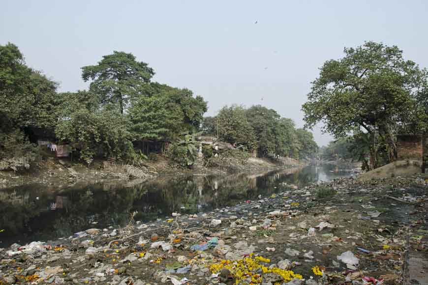
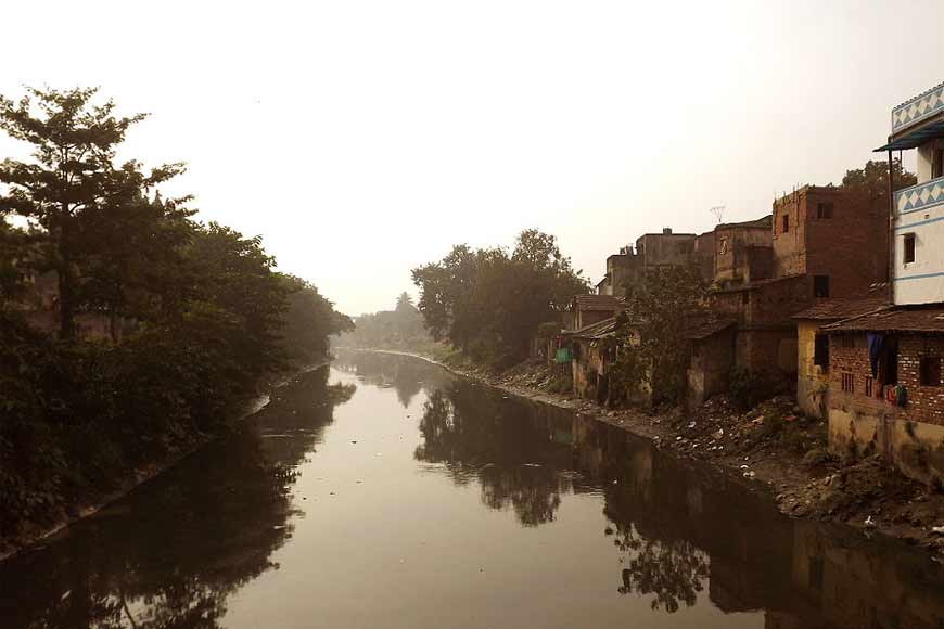
Like Saraswati, another stream drying up fast closer to Kolkata is the Adi Ganga, also known as Gobindapur Creek, that was the main flow of Hooghly between 15th-17th century but has subsequently dried up. In 1717, Edward Surman, excavated the creek and later the nullah was deepened by Colonel William Tolly in 1773 and connected to the Circular Canal. In 1775, Tolly connected the Adi Ganga to the Vidyadhari. But neglect of waterways in general and other factors such like population pressure and unplanned urbanisation caused further silting of Adi Ganga. It ultimately turned into a sewer channel for the south-western part of Kolkata.
However, we shall never learn from our past mistakes. The plans to extend the southern end of the Metro by 8.5 kilometres to New Garia recently, needed rakes on an elevated track laid over a row of concrete pillars on the bed of Adi Ganga. Except the terminal one, all the five stations on this new stretch are elevated. This could have been avoided and the pillars could have been built on the adjoining land. The action further impeded the movement of water.
Despite history of cleaning up the country’s largest and holiest river and three decades of government action plans and billions of investment later, Ganga is getting dirtier. And so are its primary tributaries like Yamuna. The only way left now is to concentrate on ways to restore the flow of the Ganga and rejuvenate the natural processes and functions of the river system. Renowned Canadian river conservationist Mark Angelo says, “Rivers are the arteries of our planet; they are lifelines in the truest sense.” So, on World River Day, let us all come together and pledge to take care of our rivers to save our planet from extinction.


