


First Land mapping of India started in Bengal by none other than Radhanath Sikdar - GetBengal story

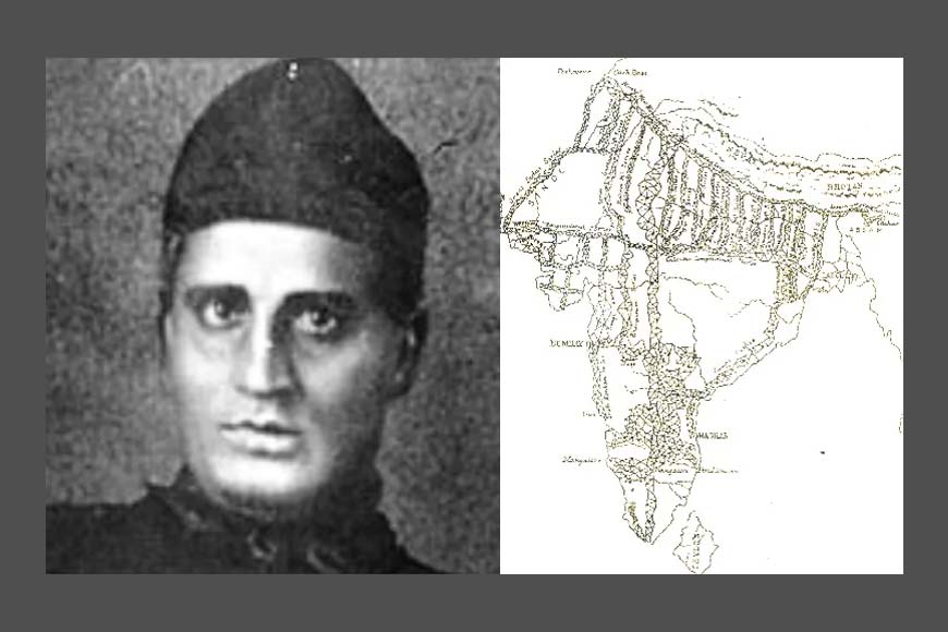
Mountaineers and the authorities at the Himalayan Mountaineering Institute (HMI), Darjeeling and the Radhanath Sikdar Himalayan Museum have been pitching for renaming Mount Everest after Radhanath Sikdar, the mathematical genius who was the first person to calculate the height of Mount Everest, in 1852. Sikdar, a student and a master in spherical trigonometry from Kolkata’s Hindu College was handpicked for the survey department in 1831. George Everest, the then-Surveyor General of India, was looking for a mathematician who had specialized in Spherical Trigonometry, so that he could be a part of the Great Trigonometric Survey. In 1832, under the leadership of Everest, the longitudinal series of the "triangle" survey was completed from Sironj in Central India to Calcutta. While still working on mapping Calcutta, Everest met Professor John Tytler, a professor of Mathematics at the Hindu College. Tyler recommended his 19-year-old pupil, Radhanath Sikdar.
Radhanath was one of the first two Indians to read Isaac Newton's Principia and by 1832, he had studied Euclid's Elements, Thomas Jephson's Fluxion and Analytical Geometry and Astronomy by Windhouse. Taking inspiration from these prestigious papers, he devised a new method to draw a common tangent to two circles, when he was just a teenager. There was little doubt about Radhanath's proficiency in his subject, and he secured the job at the GTS on 19 December 1831 as a ‘computer’ at a salary of Rs 30/- per month.
In India, use of maps was detected during the Indus Valley civilization. In 300 BC, Greek monarch Alexander the Great ordered Greek mathematician Eratosthenes to prepare the map of India. After Eratosthenes, Ptolemy came to India and tried his hands at creating the map. Then there was a long hiatus. The actual professional process of map-making started during the British colonial period. In 1757, the British East India Company defeated Nawab Siraj-Ud-Daula in the Battle of Plassey and conquered Bengal. After consolidating their jurisdiction, the British now wanted to collect taxes from their subjects. However, due to lack of maps, they did not know the border region of the land properly. Therefore, it was decided to prepare the map of India and in 1767, the Survey of India was formed for this purpose.
Also read : The man who made Mount Everest famous
Major James Rennell (1742-1830), regarded as the ‘Father of the Indian Survey,’ carried out the first comprehensive geographical survey of much of India. It was a massive undertaking that mapped parts of India at a greater detail than many European countries had been mapped till then. His survey led to ‘The Great Trigonometrical Survey of India’ which began in 1802. He is renowned for his Bengal Atlas of 1779 and Memoir of a Map of Hindoostan (1782). The map of Hindoostan included not only India, Pakistan, Bangladesh but also many neighboring countries in the South Asian regions like Afghanistan, Burma, Sri Lanka, and Myanmar where the British Empire had an imperial and economic interest.
Renell continually updated his maps for accuracy and added new geographical information, using indigenous maps and drawings as sources for his maps of the Punjab region. His cartographic methods included gleaning information from earlier maps, measuring distances along roads, establishing the coordinates of control points, and then creating a “graticule” or grid to create his maps. Rennell’s maps were of such accuracy and quality that they were used well into the 19th century.
The first trigonometric land survey began in Madras led by Lt. Col. Jack William Lambton of the British Army. A former student of a prestigious grammar school in the UK, Lambton was posted in India in 1796. Lambton planned to do this by creating a huge grid of triangles in straight lines from Cape Comorin in the south to Dehradun in the Himalayas, called the Great Meridional Arc. Lambton's survey method was called the Great Trigonometric Survey (GTS). Despite working for 18 consecutive years, Lambton could not even complete one-third of India's map. The survey was finally completed in 1870, many years after Lambton's death (1823). Much of the triangle had to be resurveyed due to inaccuracies. During the project, it became evident that it was possible to measure, classify, calculate and reasonably explain.
After Lambton’s superannuation, his former assistant and successor, George Everest, carried forward his work. He started his stint under Colonel Lambton in 1806 and a few years later, became the Surveyor-General of India. After this, he could command all the geological and surveying missions in India. He completed the Great Trigonometric Survey of India in the area wider than 2,400 kilometers starting work in 1806. During his term as surveyor general, Everest introduced the most accurate surveying instruments of the day.
Apart from the charts and maps created during the GTS, there are two visible pieces of evidence of the land survey. Two survey towers still exist on the road from Kolkata to Barrackpore. As the area is remarkably flat, it was not possible to establish a baseline from which to start the measurements. Therefore, two towers measuring 75 feet high were built and observations were made from their roofs. George Everest retired in 1843 and was succeeded by Colonel Andrew Scott Waugh. At the order of Colonel Waugh, Radhanath started measuring the height of mountains.

The brilliant mathematician, who had perhaps never seen Mount Everest, discovered in 1852 that Kangchenjunga, which was considered to be the tallest in the world, wasn’t really so. Compiling data about Mount Everest from six observations, he eventually came to the conclusion that it was the tallest in the world. It was during the computations of the northeastern observations that Radhanath had calculated the height of Peak XV at exactly 29,000 ft (8839 m), but Waugh added an arbitrary two feet because he was afraid that Sikdar’s figure would be considered a rounded number rather than an accurate one. He officially announced this finding in March 1856, and this remained the height of Mount Everest until an Indian survey re-calculated it to be 29,029 ft or 8848 m in 1955.
Seventy-five years after India won Independence on 15 August 1947, the country’s internal boundaries have undergone continuous evolution over the past seven decades, The biggest reorganization occurred in 1956 when an official States Reorganization Act was implemented. However, even after that, there were several changes in state boundaries.


